Jurisdictional Lines Overview
South Carolina’s beaches are dynamic places, some beachfront areas accrete or gain sand while other shorelines erode. The coastline changes over time due to tides, waves, currents, tropical weather systems, as well as beach use and maintenance activities. South Carolina Code of Laws § 48-39-280 requires DHEC’s Office of Ocean and Coastal Resource Management to establish and periodically review two beachfront jurisdictional lines.
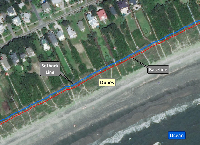
There are two beachfront jurisdictional lines - the baseline and the setback line. The baseline is the more seaward (towards the ocean) of the two jurisdictional lines, while the setback line is the more landward (towards the land) line. The purpose of these lines is to delineate the extent of DHEC's direct permitting authority for activities within the defined beach/dune system critical area. South Carolina’s beachfront jurisdictional lines enable DHEC to implement laws and regulations that support the state's beachfront management goals and protect vulnerable shorelines and natural ecosystems within this critical area.
It is important to be aware that in addition to the beach/dune system critical area, there are two other beachfront critical areas in South Carolina, beaches and coastal waters, in which the Department has authority to review activities. DHEC staff are available to assist citizens in understanding the lines and the authorization process associated with specific property and specific activities within all of the beachfront critical areas.
Beachfront Management Reform Act
On May 3rd, 2018, Act 173, the Beachfront Management Reform Act, was signed by Governor Henry McMaster. This Act established the position of the state’s beachfront jurisdictional baselines and setback lines for the 2018 establishment cycle. Act 173 also included a section that requires DHEC to promulgate regulations to implement provisions of the act, including regulations that DHEC will use to locate a primary oceanfront sand dune.
Stakeholder Engagement
To initiate input into the regulatory development process, DHEC convened a Beachfront Jurisdictional Line Stakeholder Workgroup (Workgroup) between October 2018 and February 2019. The Workgroup was tasked with providing recommendations to DHEC to: 1) clarify the definition of a primary oceanfront sand dune, and 2) develop strategies to qualify and measure “extraordinary erosion” as referenced in S.C. Code of Laws § 48-39-280(E)(4).
The Workgroup was comprised of a diverse group, representing a variety of backgrounds and constituencies, including local government, private consultants, engineering companies, the real estate community, community associations, legal professionals, and environmental and conservation organizations.
A series of eight workgroup meetings were held between October 2018 and February 2019. Meetings were open to the public and noticed on DHEC’s public notice webpage. All meetings were held from 10:00 a.m. to 2:00 p.m. at the DHEC OCRM office in North Charleston, except for the final meeting, which was held at the Charleston Main Library in downtown Charleston. Meeting agendas and notes captured at each of the eight public meetings are provided below.
Final Report and Recommendations
The Workgroup examined an extensive amount of background information and available data to assist with member participation and discussion. A summary of this information, details of the Workgroup’s discussions, and the group’s final recommendations were documented in the Beachfront Jurisdictional Line Stakeholder Workgroup Final Report (May 2019).
The final recommendations assisted DHEC with formulating regulations to implement the provisions of the Beachfront Management Reform Act.
Recommendation 1
For the purposes of establishing the beachfront jurisdictional baseline within the standard zone and stabilized inlet zone, primary oceanfront sand dunes constitute the most seaward dune ridge adjacent to the Atlantic Ocean that is nearly continuous for 500 linear feet*; typically exhibits the presence of stable, native vegetation; and has a dune height of 3 feet as measured from the seaward toe to the crest of the dune. The primary oceanfront sand dune is typically not scarped, eroded, or overtopped by the highest predicted astronomical tides but may be inundated by storm surge, which normally accompanies major coastal storm events.
Emergency berms that have been created as temporary barriers do not constitute a primary oceanfront sand dune unless the berm is situated along the historical footprint of the natural dune system and exhibits the characteristics of the defined primary oceanfront sand dune.
*Nearly continuous sand dunes are defined as generally undissected dune ridges but may exhibit minimal breaks such as those resulting from pedestrian and/or emergency vehicle access points.
Recommendation 2
In standard and stabilized inlet zones, if the primary oceanfront sand dune is located more than 200 feet landward of the current line of stable vegetation, the jurisdictional baseline should be established seaward of the primary dune a distance equal to 30% of the measured distance from the primary dune to the current line of stable vegetation.
Recommendation 3
In standard and stabilized inlet zones on developed beachfronts, if no primary oceanfront sand dune exists, the upland location of the crest of the primary dune should be located by using the ideal dune analysis* of a volumetric calculation for a 3-foot-high reference dune. After this analysis is completed, the baseline should be established at the crest of the ideal dune. If the ideal dune analysis establishes the baseline landward of a habitable structure, then the baseline should be placed at either the seaward edge of the habitable structure or the landward edge of the active beach, whichever is further landward. The baseline should not be set seaward of its position established by Act 173.
In standard and stabilized inlet zones on essentially undeveloped beachfronts, if no primary oceanfront sand dune exists, the baseline should be established at the current line of stable vegetation.
*The ideal dune analysis is currently in regulation (S.C. Code Ann. Regs. 30-21(H)(2)) and has been used in previous line review processes.
Recommendation 4
At the initiation of a jurisdictional line review cycle, communities may submit a request for an extension of the jurisdictional line review for their community if they have an issued DHEC OCRM Critical Area Permit that is in effect for a renourishment project, or a federal renourishment project with an associated state-issued Coastal Zone Consistency Certification. The purpose of the extension is to allow construction of the renourishment project to be completed and the beach/dune system to begin to stabilize. The community requesting the extension must demonstrate that 1) funds are encumbered to complete the renourishment project, and 2) the project will be initiated within one (1) year as demonstrated through a ratified agreement with a construction contractor. Local governments are encouraged to communicate with DHEC OCRM regarding pending renourishment projects, including during the update of the community’s Local Comprehensive Beachfront Management Plan. This coordination would inform the development of the jurisdictional line review schedule.
Recommendation 5
DHEC OCRM should evaluate and implement provisions for extraordinary erosion on an island or beach geographic scale. DHEC OCRM should implement a framework to coordinate with local governments and other government entities to obtain pre- and post-storm data to assist with 1) establishing typical erosion along an island or beach, and 2) determining when extraordinary erosion events have occurred along an island or beach.
The final recommendations of this workgroup will assist the Department with formulating regulations to implement the provisions of the Beachfront Management Reform Act. The Department will provide notice to the public of the formal regulatory development process including opportunities for public input.
Regulatory Changes
In 2020, DHEC amended R.30-1.D(43) and R.30-14.E., F., and G. to incorporate state statutory changes. The amendments provided clarity and standards to be utilized in the establishment of the state’s beachfront jurisdictional lines. The amendments also modified specific procedures related to appeals and movement of the jurisdictional lines to comply with Act 173 and Coastal Zone Critical Areas, Act 197 of 2016.
Meeting Agendas and Notes
Tuesday, February 26, 2019
Monday, February 4, 2019
Wednesday, January 23rd, 2019
Friday, January 11, 2019
Wednesday, December 5, 2018
Wednesday, November 14, 2018
Wednesday, November 7, 2018
Wednesday, October 24, 2018
Historic Workgroups and Committees
- Beachfront Preservation Stakeholder Workgroup
- Blue Ribbon Committee on Shoreline Management
- Shoreline Change Advisory Committee
- Council on Coastal Futures
- Blue Ribbon Committee on Beachfront Management