Groundwater is part of the water cycle (Figure 1). A portion of precipitation that lands on the ground moves downward through the ground until it reaches a saturated zone (every opening such as space between grains of sand or every fracture in the bedrock) that is filled with water (see Figure 2).
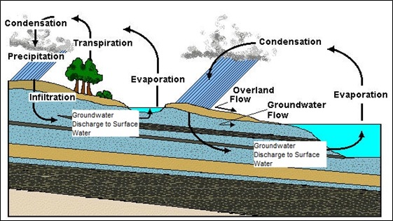
Figure 1
In South Carolina, our state is divided into two distinct physical geographic regions, the Mountains/Piedmont and the Coastal Plain (see Figure 3). In the Mountain and Piedmont region of the state, groundwater occurs primarily within the fractures of rock. The shallow/water-table aquifer occurs at the transition zone between the weathered soils and the bedrock.
The groundwater aquifers of the Coastal Plain are primarily unconsolidated sediments (sands, silts, and clays) and some sedimentary rock such as limestone. Figure 4 shows a depiction of the major groundwater aquifers in the South Carolina Coastal Plain. The aquifers thicken and become deeper as you move from the boundary of the Coastal Plain and the Piedmont towards the coast.
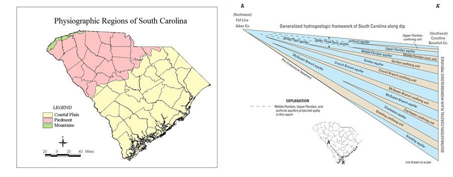
Figure 3
Aquifers are recharged from precipitation and can be confined or unconfined (Figure 4). Unconfined aquifers are more connected to surface waters and influenced by climate. Confined aquifers are separated from the surface systems and are less impacted by short-term variations in climate.

Figure 4
Groundwater management systems work to balance deposits and withdrawals. Deposits come from natural sources of precipitation and surface waters, while withdrawals stem from natural, community, & industrial uses. Capacity use designations provide a planning tool for promoting best practices and long-term resource evaluation.

Figure 5